|
|
 |

|
|
About 6km, About 3hrs. : From Mikisato Station to Kata Station
--- Easy walk |
|
|
This trial is taken cared by local people in Kata-cho (a distination of
this trail), so it's a very nice and comfortable trail. Yokone-michi Path,
a part pf this trail, was found by them in 2003.
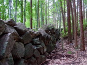
Miki-toge Pass has a good stone path and a viewing point. Hago-toge Pass
is famous for its "Shishi-gaki," which seems the longest in this
Area.
Between two passes there was a stone path and much of it is collapsed.
But some part remains and you can enjoy it. |
| "Miki-toge/Hago-toge Pass Trail" brief Map |
|
 click a map and you can see a big PDF map for printing click a map and you can see a big PDF map for printing |
|
| Mikisato Station ->(slight downhill and uphill, paved road, 15mins.)-> Entrance to Yokone-michi Path ->(slight uphill and downhill, unpaved and paved road, 30mins.)->
Starting Point ->(uphill and downhill, unpaved road-partly stone path-paved road-unpaved
road, 90mins.)-> Hago-toge Pass ->(downhill, unpaved road-partly stone path, 30mins.)-> Juncture of Paved Road ->(slightly downhill, paved and unpaved road, 25mins.)-> Kata Station |
|
|
| by car |
Nagoya ==(Highway & Route 42 / 3hrs. and 25mins.)== Owase Station ==(30mins.)==
Mikisato Station
>Owase Station ==(25mins.)== Kata Station |
| by train |
Nagoya Station ==(Nanki Express / 2hrs. and 30mins.)== Owase Station
==(Local / 20mins.)== Mikisato Station ==(Local / 5mins.)== Kata Station |
|
|
|
 |