|
|
 |

|
|
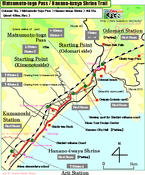
About 4.5km, About 2hrs.: From Odomari Station to Arii Station
--- easy walk |
|
|
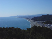
From Odomari station to Arii station, there are many things to see through
this trail - good stone path, nice view from the summit of Oni-ga-jo castle,
Shishi-iwa Rock, Hanano-iwaya Shrine, and so on.
Though there is short steep slope from Odomari to Matsumoto-toge Pass,
you don't need much physical strength. |
| "Matsumoto-toge Pass trail" brief Map |
|
 click a map and you can see a big PDF map for printing click a map and you can see a big PDF map for printing |
|
| Odomari Station ->(uphill, paved road, 10mins.)-> Starting Point(Odomari side) ->(uphill, stone path, 30mins.)-> Matsumoto-toge Pass ->(downhill, unpaved road and stone path, 20mins.)-> Starting Point(Kinomoto side) ->(even, paved road , 15mins.)-> Kumano-shi Station ->(even, paved road, 40mins.)-> Hanano-iwaya Shrine ->(even, paved road, 20mins.)-> Arii Station |
|
|
| by car |
Nagoya ==(Highway & Route 42 / 4hrs.)== Odomari Station ==(Route42/5mins.)==
Kumano-shi Station ==(Route42/5mins.)== Hanano-iwaya Shrine |
| by train |
Nagoya Station ==(Nanki Express / 2hrs. and 30mins.)== Owase Station
==(Local / 43mins.)== Odomari Station ==(Local / 5mins.)== Kumano-shi
Station ==(Local / 4mins.)== Arii Station
>Nagoya Station ==(Nanki Express / 2hrs. and 50mins.)== Kumano-shi
Station |
|
|
|
 |